
Trace Ogden Streets by Address
A street-by-street search begins with the physical parcel. The address is then checked against the Town of Ogden assessment roll, the Monroe County map, and the land index. Each layer has a different date and purpose. The roll identifies an owner and mailing address for its roll year. GIS establishes where the parcel is drawn and which municipality layer covers it. A deed documents a transfer of land. A directory or census can provide dated household evidence, but none of those sources alone establishes a present occupant.
- Enter the current address in the Monroe County Parcel Viewer. Save the address, legal municipality, and parcel identifier returned with the parcel.
- Use the parcel key or situs address in the Town of Ogden Assessor route and the County real-property portal. Compare the property address with the owner mailing address rather than treating either as a current-resident list.
- Record the GIS historic book and page fields, then use those references in the Monroe County Clerk land-record index to locate the deed trail.
- Read the deed parties, recording date, legal description, and prior reference. A grantee in one conveyance may become the grantor in the next.
- For a dated address-to-household lead, consult the relevant directory street section or census year. The historical collections are described with their access limits in the Ogden City Directories.
- Use the Monroe County voter lookup only for its individual election-service function. It requests an address, name, and date of birth, and it is not an open roster for a whole street.
That order protects against a common mistake: moving directly from a parcel owner or mailing address to a statement about who presently lives there. The evidence must remain tied to the date and field that the custodian actually publishes.
Use Ogden Assessor Street Fields
The Monroe County Real Property Portal, linked by the Town Assessor, supplies parcel inventory and sales data after registration. The annual roll is the clearer dated record for an address search. It can show the owner name, owner mailing address, parcel size, land and total assessment, taxable values, exemptions, and special districts. A roll is an assessment snapshot, not an occupancy register.
| Field | Type | Required | Options and use |
|---|---|---|---|
| Owner/name | Text | No | Search a current or roll-year owner; spelling variants matter. |
| Situs/property address | Text | No | Use the street number, street name, and municipality as the portal allows. |
| Parcel/tax key | Text | No | Use the stable link between assessment, GIS, and deed research. |
| Sale-search | Filter/date | No | Review valid and non-valid sales, retaining the sale type and date. |
| Roll-year | Selector | No | Select the annual assessment snapshot needed for the question. |
| Exemption | Category/status | No | Read exemption status as a roll field, with timing maintained by the Assessor. |
Sale status needs context. The Assessor describes non-valid sales as including foreclosures, most estate sales, and other forced sales. A sale row therefore cannot stand alone as a typical market comparison. The Town page displayed an Ogden and Spencerport valid-residential-sales range from July 1, 2021 through January 26, 2024 when inspected.
Note: Assessment fields should always be cited with the roll year because values, exemptions, and mailing information can change.
Read Ogden GIS Parcel Layers
The public Monroe County parcel feature layer provides a second address route. Its published fields include COUNTYSBL, PrintKey, SWIS, parcel address, postal city, ZIP, acres, roll year, total assessed value, and historic book and page. The viewer also offers parcels, Towns and Villages, ZIP codes, roads, buildings, water, rail, parks, imagery, and topography. A map is useful geography, but it is neither a survey nor proof of title or occupancy.
See the public parcel feature-layer record screen before using those fields.
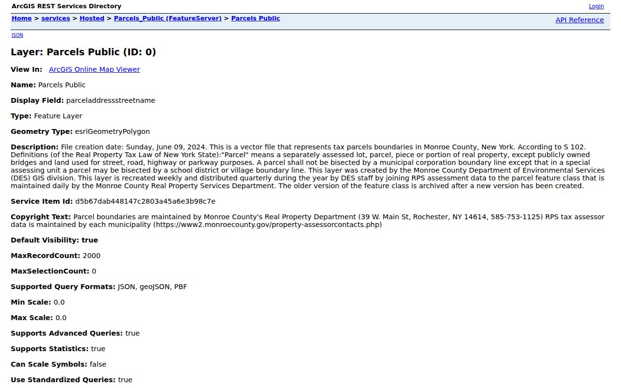
The feature-layer view shows why the parcel key and historic book and page are more durable research notes than a display label alone. Save the returned value with the query date and roll year, since the public parcel layer is refreshed over time.
Compare Ogden Street Records by Address
Address-keyed sources can be read in sequence. The assessor supplies a roll snapshot, GIS supplies parcel geography, and the County Clerk supplies land instruments. Municipal files and dated historical sources add context when they are available. The table keeps the limits visible, which matters more than trying to combine separate records into a current household list.
| Address-keyed record | Custodian | What it can show | Access route |
|---|---|---|---|
| Annual assessment roll | Town Assessor / Monroe County RPTS | Owner, mailing address, parcel size, assessed and taxable values, exemptions, special districts | Annual roll or County portal; registration may be required |
| Public parcel GIS | Monroe County GIS | Boundary, situs address, ZIP, acreage, dimensions, roll year, historic book/page | Viewer, public feature layer, and map query |
| Deed or map record | Monroe County Clerk | Grantor, grantee, recording date, legal description, Liber/book and page | Index, public terminal, or copy request |
| Building or planning file | Town of Ogden Building Department | Permit, certificate, inspection, site-plan, subdivision, or zoning lead | Application channels, counter, or records request |
| Directory street section | Library and local collections | Dated house number, listed surname, and street sequence | Bound, digitized, or in-library volume |
| Census or newspaper | Archive or library collection | Dated household or community mention | Digitized, microfilm, or local collection |
A parcel or tax key is the practical bridge across these records. The street name connects a human-readable address to the map and older volumes, while the book and page can lead from GIS to the Clerk. Read any directory entry as a source dated to its publication year, not as a replacement for an official land record.
Define Ogden Street Record Terms
Address records use a few technical labels that are easy to confuse. Keeping the terms separate prevents a map field, a title reference, or a library listing from being asked to prove more than it can. These definitions follow the roles used in the Town and County records.
- Parcel
- A defined piece of land represented by a tax-map or parcel key. It is the practical bridge between the assessment roll, GIS layer, and land records.
- Situs address
- The physical property address carried for the parcel. It can differ from the owner mailing address.
- Plat
- A recorded map or subdivision plan that can describe lots, streets, and legal boundaries. A plat is not the same as a survey of current conditions.
- Criss-cross directory
- An address-first directory arrangement that lists entries by street and number for a stated publication year.
Check Ogden Town Village Geography
Town of Ogden and Village of Spencerport are not interchangeable record labels. Spencerport is an incorporated village within the broader Ogden area, and its name can also appear as a mailing or community label. Before following a permit, code, or parcel lead, turn on the Parcel Viewer’s Towns and Villages layer and identify the legal municipality. The same check prevents a postal city from being mistaken for a governmental boundary.
This is a geography safeguard as well as a records step. The Town’s 2024 comprehensive plan describes a rural area shaped by farmland, hamlets, parks, and the Erie Canal, while the map layers locate the parcel within that setting. Those labels give context to an address without changing which office holds the file.
Follow Ogden Deed Chain Access
The Monroe County Clerk is the official registrar for deeds, mortgages, assignments, satisfactions, judgments, liens, and maps. For newer land research, start with the online index and the parcel’s historic book and page. The County’s house-history material says online land transactions run from February 1984 to the present, while its historical deed guide describes a post-1975 digital route. Because those official descriptions do not perfectly align, ask the Clerk about the exact interval for the parcel rather than assuming a single online start date.
For earlier deeds, use the Clerk’s microfilm and index books. The backward search follows the grantor and grantee, legal description, and prior instrument through Monroe County’s 1821 creation. Land before that date may require Ontario or Genesee County microfilm. A deed transfers an interest in land; it does not establish a building date or document every person who lived at the address.
Copies can be requested through the County Clerk document order form, at the public counter, by telephone, fax, or mail. Ordinary copies are $0.65 per page with a $1.30 minimum. Certified copies are $5 for up to four pages and $1.25 for each additional page. A Clerk staff search adds $5 for every two years searched.
Use Ogden Clerk Access Changes
Access now differs between a search index and a document image. The County Clerk subscription notice says that, beginning April 1, 2026, guests can search indexing without charge while digital document images require a paid subscription. County public terminals continue to provide full index and image access at no cost. That distinction can save a researcher from paying for an image before confirming that the index entry is the right instrument.
The same release announced a free fraud-alert service by name or property. An alert can notify a property owner about a filing, but it is not a title opinion. For address work, retain the deed’s actual references and confirm them through the Clerk’s record channels.
Request Ogden Building File Records
The Town of Ogden Building Department accepts permit applications online, in person, by email, and by U.S. mail. Its published contact routes are useful when an address points to a construction, inspection, certificate of occupancy, site-plan, subdivision, or zoning file. The Town’s public materials did not show a searchable historical permit index, so the absence of a web result should lead to the documented access channels rather than to a conclusion that no file exists.
For an existing municipal record, use the Town’s FOIL forms and permits route or contact the Town Clerk with a focused request for the record category, address, and time range. NY Freedom of Information Law requests seek records already held by the agency; they do not require the Town to create a new street list or answer a broad question.
Note: A subdivision or planning file may explain an address change, but it still needs the parcel and date checked against the current map.
Test Ogden Street Name Variants
Older sources may use a former number, an abbreviated road name, a rural route, a post-office clue, or a nearby landmark. Search both the printed historical form and the current mapped form, then compare adjacent parcels and subdivision maps. The Monroe County historian notes that Rochester directories for 1884-1885 printed old and new numbers during a renumbering. That is a useful normalization method, but no official source in the research set established that the same event occurred on Ogden streets.
For a canal or hamlet address, the Town/Village layer and road, water, and rail layers can help locate the historical context. Keep the original wording in the research note, including the date and source. Do not silently convert an old postal or street label into a current legal description.
Respect Ogden Street Search Limits
A street directory can connect public, dated records, but it cannot supply a reliable current roster. The parcel roll may name an owner or a mailing address. A deed shows a land transfer. A directory or census can place a household at an address for a stated period. The voter service is an individual lookup with access restrictions, and protected registrations can produce no public match. Keep separate record types separate.
Review the Monroe County voter lookup form before relying on it for an election-service question.
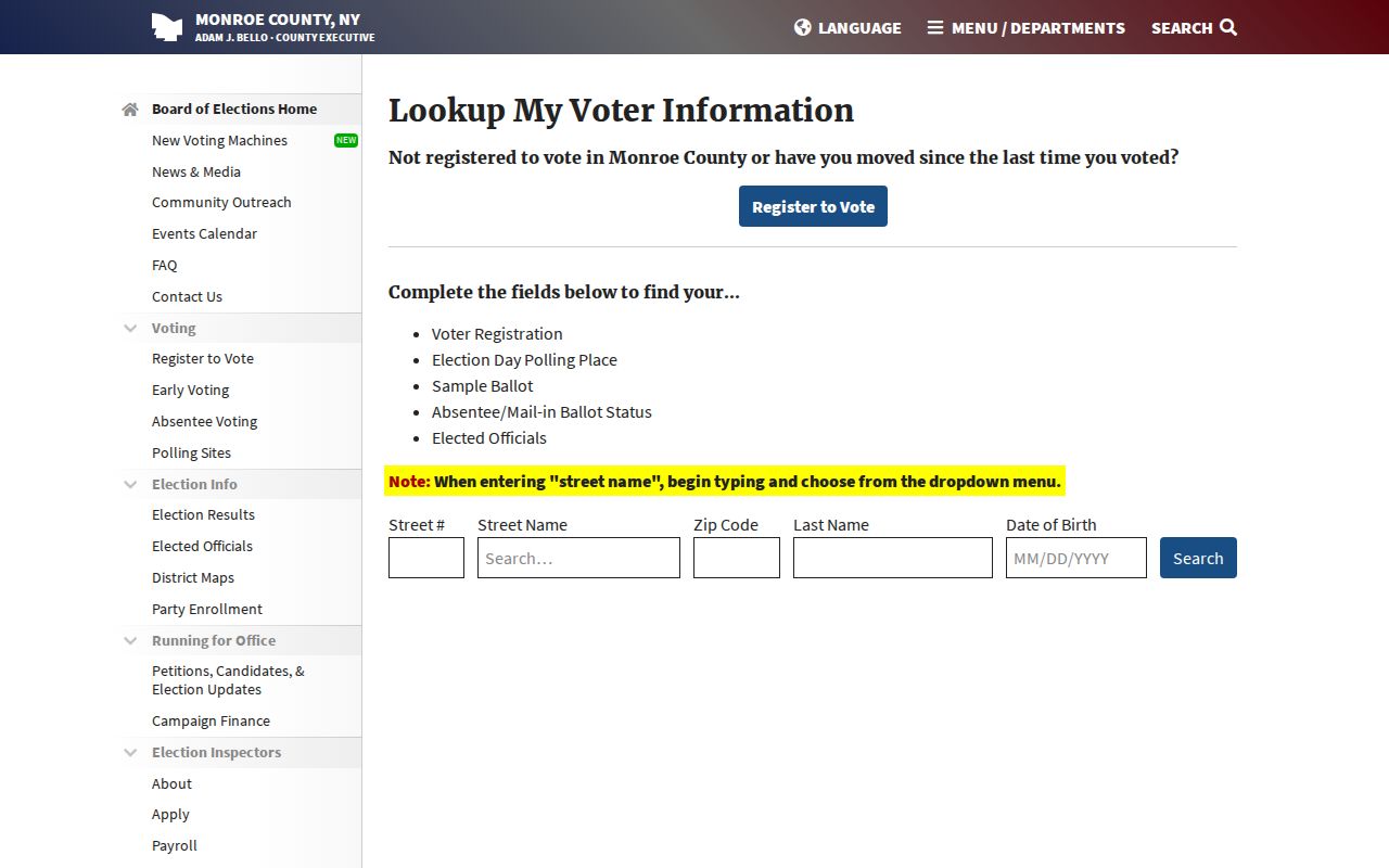
The form requires Street #, an autocomplete street name, ZIP, last name, and date of birth. Those fields show why it is designed to check an individual voter’s service information, not to browse a street for names.
Lawful personal use. Use address records for legitimate personal research, property history, or civic questions. Do not use them to stalk, harass, intimidate, or harm anyone, and do not publish more personal detail than the source and purpose require.